Remote Sensing
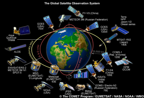
This section focuses on remote sensingthe primary method of observing weather and climate across the global tropics. We will explore how remote sensing is used and examine the types of information that it provides over formerly data-void regions. Both satellite and radar imagery are important tools along with other data sources in analyzing the state of the atmosphere and for monitoring changing conditions. Throughout the forecast process, remote sensing data can provide information about hazards to aviation such as low clouds, precipitation, dust and volcanic ash.
Each link will open a new tab or window, close the tab or window to return.
- Introduction to Remote Sensing
- Radar in the Tropics
- Clouds and Precipitation
- Dust
- Volcanoes